
MiniMetro
Stress relief, zoning, and flow

I don't have a lot of free time for games but I also don't like for my mind to idle for too long. (I need to get better at sitting with myself again…) The latest game I stumbled onto is a transit simulator. The longer I play, the more I see how well it captures the entire scope of regional transportation planning.
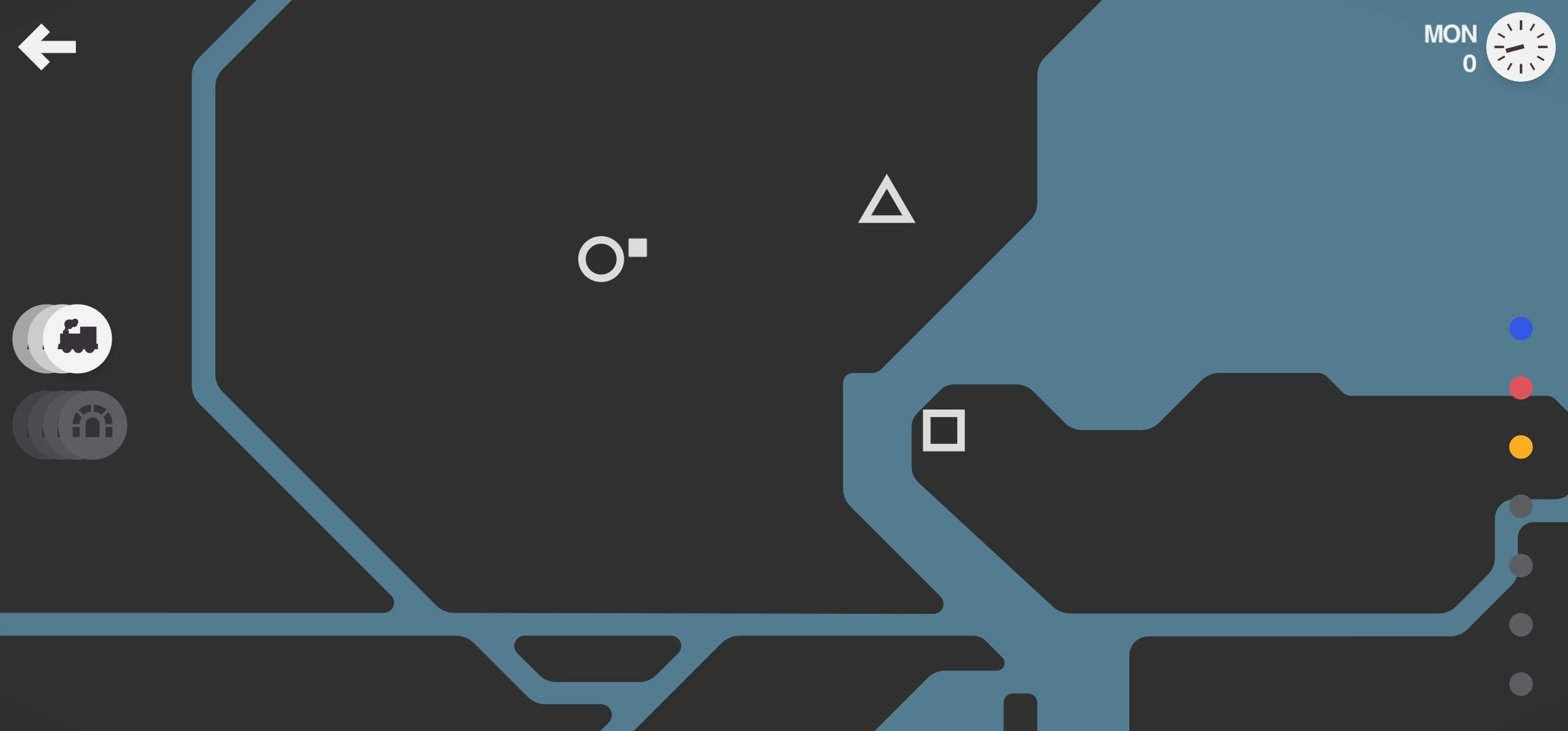
You start with a geographic area-land and water. The land is fair game. The water requires bridges or tunnels.
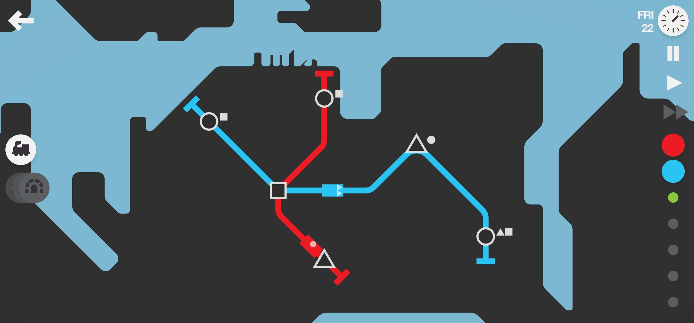
Open squares, circles, and triangles pop up in the space over time and you are given 3 initial transit lines to connect them. Little filled squares, circles, and triangles pop up next to the stations representing each “rider’s” destination goal. The riders board the trains and you watch them go from their origin to their destination. Trains have limited space, so they fill till they're full and empty when riders get to their destination. People get left at stations if there's no room on the train. The game ends (you get fired!) when too many people get left too long at a station.
Games teach us more than just their own rules. You learn principles as you play through success and failure. The rules may be simple but the game play steers you toward different strategies as you win and lose. Experience teaches you the nature of the pieces and tools at your disposal and how they work together (or don’t). The gameplay does a great job of showing what planners know but may not know how to articulate or anticipate.
Let’s start with the stations:
What are these stations?
Well, obviously they're transit stops, but lets look a little closer. What is a transit stop?
Transit stops are places where people can access high speed, long distance connections, preferably on foot.
This is the most obvious issue that keeps suburbs from jumping over the hurdle from rural to urban. Transit only works if you can get a bunch of people collected together into one place so they can get on and off together.
Any line that has to stop everywhere never gets anywhere
This is why no one likes using the bus. Every access point creates friction along the line and impedes flow. If you want lots of access, the flow slows to a crawl. If you want flow, access has to be limited.
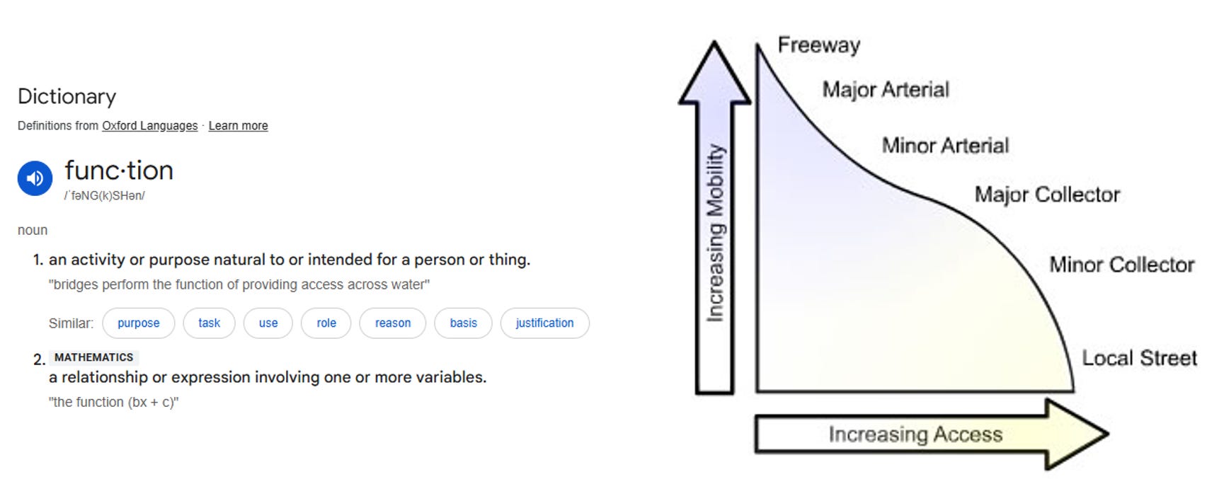
It’s a classic tradeoff and there have been a wide range of diagrams to describe it. It’s the foundational concept underneath the idea of a functional classification. The flatter and fatter the diagram is, the better the overall system works because the extremes work fine, but the middle never will. You need facilities that allow for lots of access, but they can’t be very long because they’re not going to go very fast. The most extreme example of lots of access are the lines of doorways along a vibrant city street. On the other end of the continuum are limited access highways or interstates that run between cities. Both ends work well but the stuff in the middle doesn’t. (We call them StRoads—and they make no one happy.)
There’s a StRoad equivalent in the land
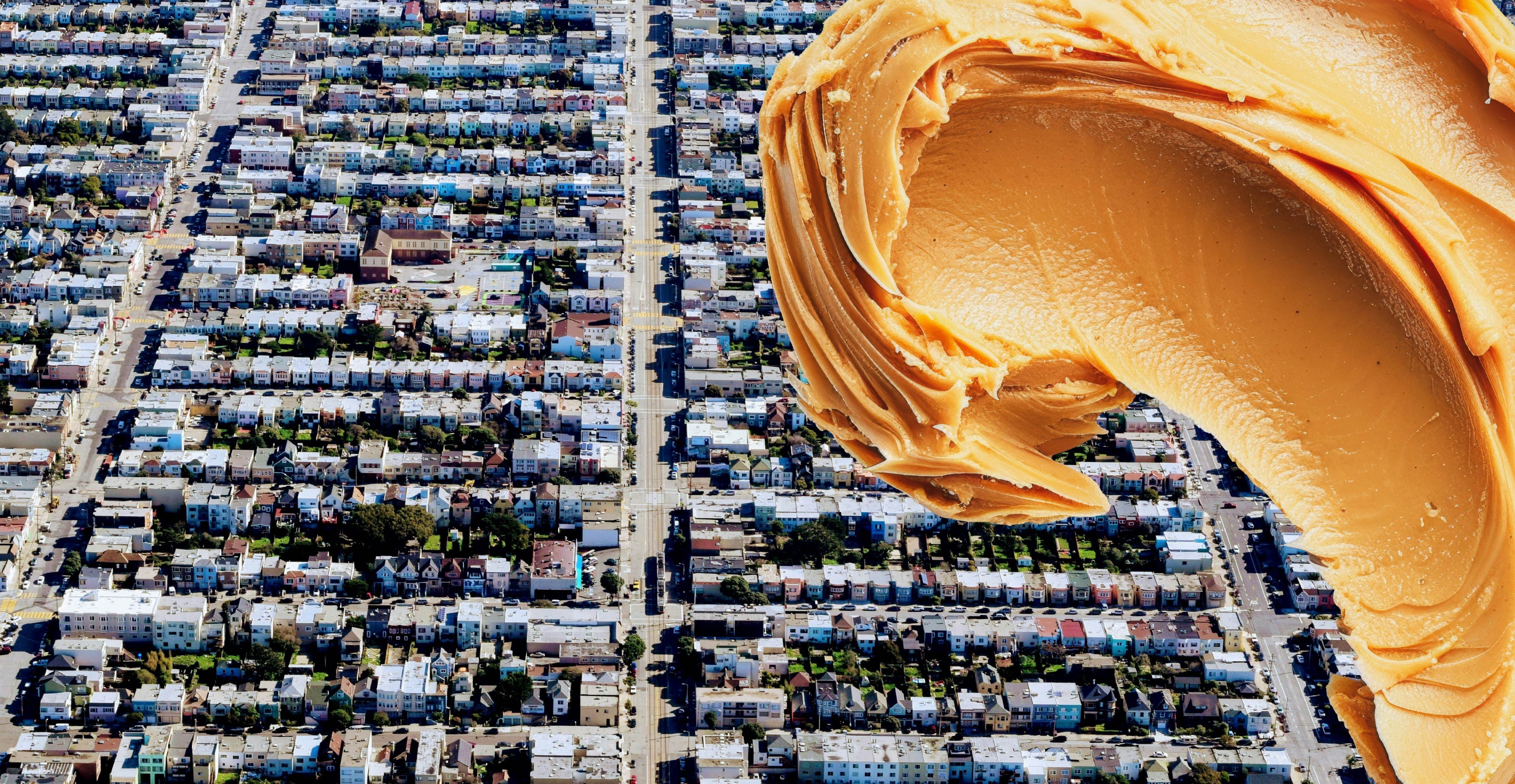
In the real world, stops have to be located somewhere you can recognize within the landscape—usually a center of some kind. If every land parcel is of equal value or importance in the landscape, it’s nearly impossible to create a transit stop—where would you put it? We call that a peanut butter smear land use and it’s not very tasty. This is what creates the middle portion of the flow/access diagram. Everyone wants to go fast, but they want the transit stop in front of their house too (or at least their next door neighbor’s house).
If you have to drive to a transit stop, it rarely works. It doesn’t make sense to leave your car at the stop and wait for a train unless there’s a real problem with having your car at your destination (like parking costs). This is where size becomes a problem.
If the land use cluster is too large, it’s hard to place a transit stop because it’s too far to walk to the center or edge where the stop needs to be.
If each parcel in a land cluster is large, the cluster is going to get too big to walk it
and there won’t be enough people in that cluster to justify stopping.
This is why planners push for high density. If you’re going to get everyone together to pick them up, there needs to be a bunch of people going the same way not to far apart from each other. Transit systems work with medium or low densities in Europe, but the land use is pretty compact and car travel is expensive. It’s rare to see it work in the US.
Density doesn’t always mean high rises—the best types of density are in the 2-3 story range with smaller lots because you can connect people up to the station and each other with far fewer cars. Cars and roads upscale everything out of walking range, making it a lot harder to get enough people gathered together to make it work. Most car-centric planners pooh-pooh transit as ineffective. What they don’t know is that transit just fails faster than cars do and is easier to fix.
In the long run, even the cars get in each other’s way and it falls apart—and that’s not that different than leaving people stuck at a transit station too long.
The Types of Stops
The game starts out with three main types of stops. The squares seem to represent town centers or major retail. Circles act a lot like residential. That means triangles are probably employment centers. For a line to succeed, you need all three on the same line. Riders are always going from one type of station to a different type. If riders need to switch trains, they’ll be waiting in the station—and that will cost you the game.
Squares are usually rare—there’s often only one of them for a long time. In most communities, the downtown core is unique and irreplaceable—at least at first. That means it’s important to make sure every line can access a square easily, if possible. Triangles (employment) are also less common, but there’s usually several of them. Residential circles pop up all over the place.
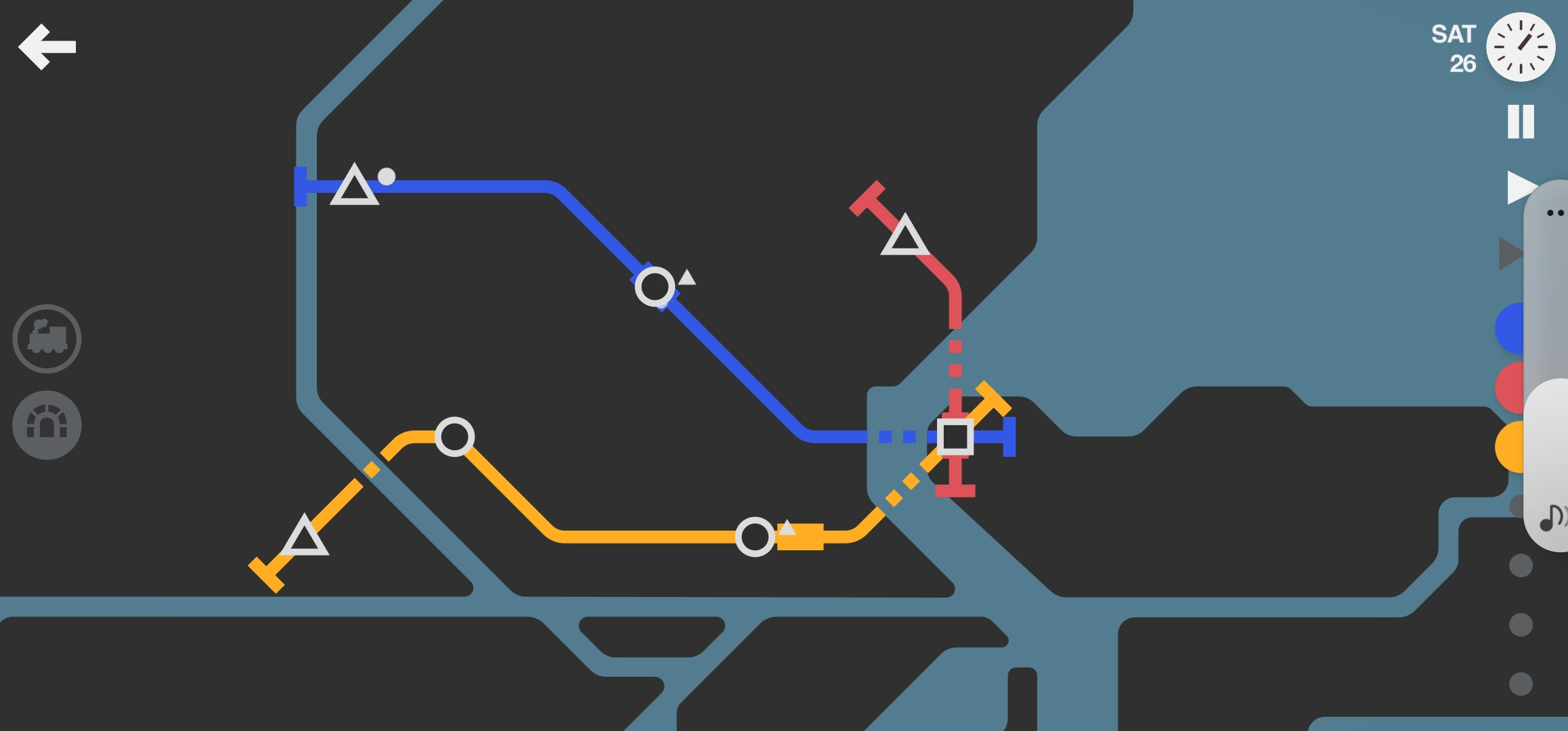
The game doesn’t start out being very picky about origins and destinations. Squares may be unique, but any triangle or circle is just as valuable as any other. (It doesn’t stay that way, but we’ll get to that in a minute.)
Expanding the System
Every Monday morning you get a new train to add to the system and a choice of one new expansion resource—a new line, a few new tunnels/bridges, or a new carriage to give you more space in the train you already have. Sometimes you can even get a high speed train.
The game gives you a choice between two of these resources—and it’s not always the resources you need. Think of this like the annual fiscal cycles. Each year you can expand your budget to meet new demands, but mid-year resource changes aren’t coming. You can only add so much at a time, and what you can get through the public review or procurement process it’s not always what you need.
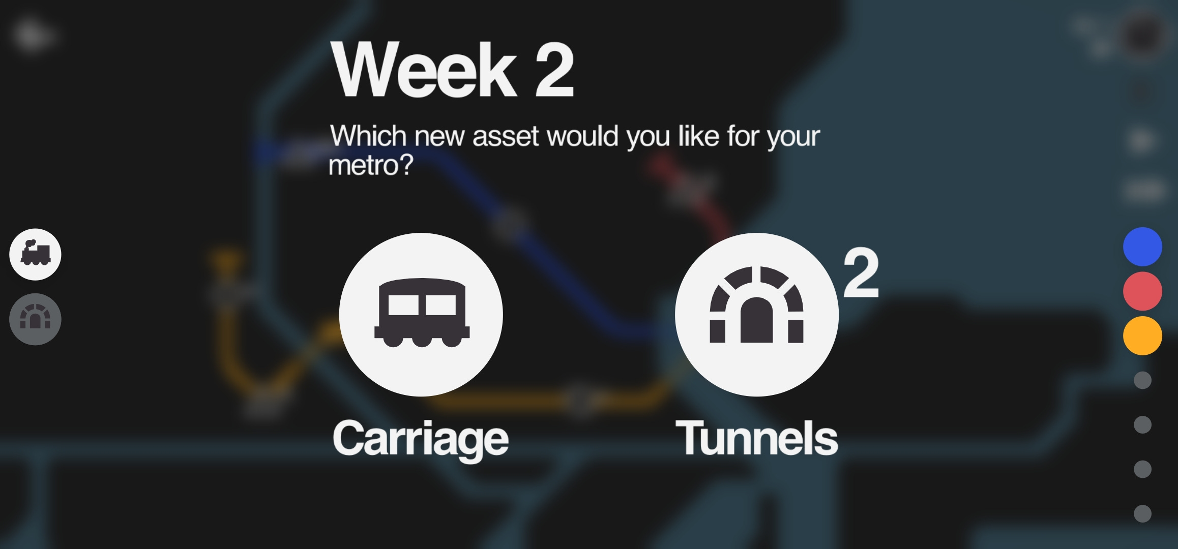
One of the hardest choices is between adding a new line or adding a new carriage to a train. This represents two different strategies for expansion—long transit lines with lots of vehicle capacity or lots of lines. A long line can connect up a lot of options, but each train has to go from one end of the line to the other, which means it takes longer for a train to get back to a station—and new stations pop up along the line which means new stops that make the time even longer. You can add cars to your train and they’ll be able to carry more, but the train still has to go along the entire route—and sometimes they bunch up, leaving people stuck for a long time. If the line gets too long, the train gets full before it gets back to the core. The stops close to the downtown stay full and get you fired.
For most of the systems in the game, lots of short lines seem to work better than a few long ones. It also gives you more options for straighter lines. Zig-zag lines look short but aren’t. So here’s another big transportation takeaway:
The shorter your trips are, the less time and track (or road) you need to make them.
Big swaths of single use types will mean long trips just to get to a different type of area. The longer the trips, the longer you’re spending making those trips and the more road you’re consuming (and maintaining). That’s why most transportation engineers are starting to look at VMT rather than simple roadway volume. Capacity tells you how much room you have in one spot. VMT looks at how much of the system space and time is going to get used. Half the trip length and you’ll lose overall congestion because you’re not using as much of the network.
That’s also why so many planners push mixed use. If you can access your destination without having to take a car or transit trip at all, then that’s less infrastructure that needs to be built or managed.
Polycentricity
Over time, some of the triangles will switch to stars, crosses, or other weird shapes—which also become unique. Think of these as unique attractions, hospitals, or specific industry clusters—like Silicon Valley or Hollywood. That means all stations must have access to that weird shape or you’ll collect riders at the station (and lose the game).
A transportation system must get you to all of the types of places you need to go.
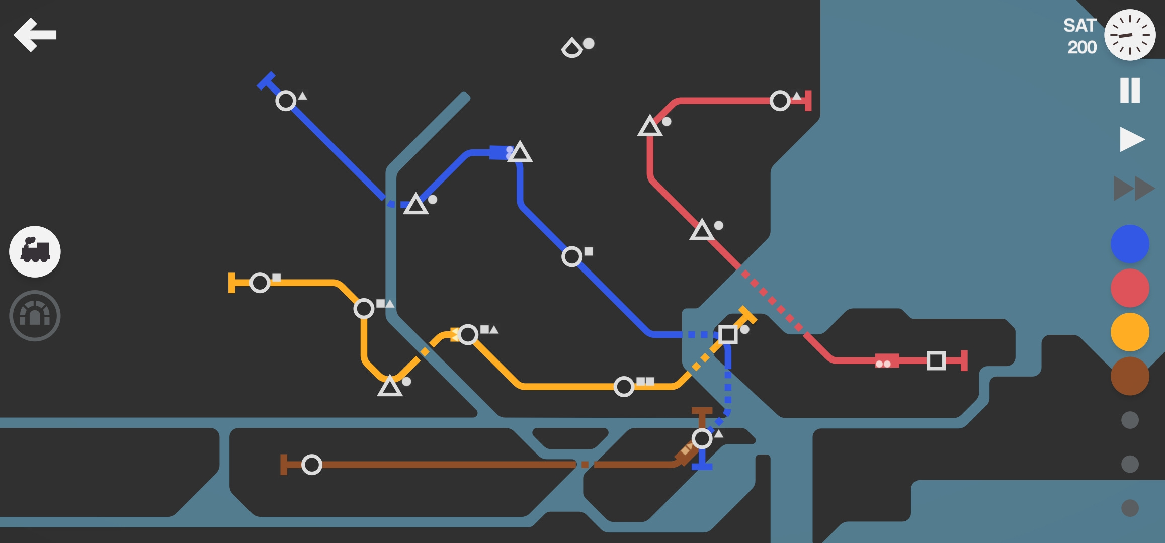
This is often where things go south fast. That red line was fine on its own—it had it’s own core—until that weird triangle with a round bottom edge popped up. I’ll need to make sure both the red line and the rest of the system can get there. At this point I’m hoping I get offered a new line on Monday morning so I can connect them all together, but I’m also out of bridges (which is why the red line doesn’t connect to the rest of the system). I’ll either have to rehash the whole thing and do a very short connection across the river into the rest of the system or it’s going to fail and soon.
Since this is the last screenshot I took, I’m pretty sure it failed not long after this.
If you look closely, you’ll see the Yellow line is also likely to fail within a week or two. It’s getting too much activity at each stop and the train will be full before it gets back to the town center. I can add another train to it, but it’s a temporary fix. The line is too long and the ends are too far from the core of the city. The stations will intensify faster than I’ll be able to keep up. As long as the city has to reach these outlying unique stations and the original core, there’s going to be struggle to serve both.
Mushy Marchetti
This is how congestion and Marchetti’s constant create inevitable failure. Marchetti’s constant tells us that cities will grow until the typical commute time reaches about half an hour. BigThink did an outstanding description of it here based on David Montgomery’s Bloomberg Article for CityLab.

What none of them have considered is the impact of congestion. As long as the two centers must interact regularly, congestion will eventually push the centers more than half an hour apart. The distance doesn’t change, but the time to get there does—and the time is all that matters.
This polycentricity problem isn’t new, but the car has made it far more obvious. So what’s the solution?
Over time, polycentric areas must reorient themselves to their own center and intensify from within. At that point they become multiple mono-centric cities—which now work on their own and can cooperate with the other new centers. Think of it as cell division—if a cell kept growing without dividing, it would eventually burst.
Now your turn!
The game was only a few dollars and was well worth the free time to make those transportation lessons come alive. (No, I’m not getting any of that money). There are 16 cities to try out and other modes that make it harder (or easier). After you’ve played a while, let me know what it has taught you. I’ll do a follow-up in a few weeks for any new insights.
I hope you all have a spectacular Thanksgiving!! There’s a lot to be grateful for and the remembering always re-energizes!! Love on someone for me this week!